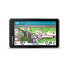
The new zūmo® XT3 is designed for the road or the track. Featuring a bright 4.7-inch display and a durable body, it's built to withstand harsh weather and vibrations.
When it's time to hit the road, use preloaded road maps and the Great Ride database to create a personalized adventure; download satellite imagery for
a bird's-eye view. Thanks to the lean angle indicator, you can review your performance at the end of your ride.
Take the twistiest, most scenic or most exciting roads with Garmin Adventurous Routing and discover the most popular routes on the map with the dedicated feature.
Prefer the track? Subscribe to the Garmin Performance Package to record lap times, splits and more with
built-in sensors (subscription required). After your session, review and share your performance details, such as lean angle, acceleration, speed, elevation and more, in the Tread® app.
View your lean angle at every turn in real time; view your ride summary in the Tread® app to review all your data, such as acceleration, braking, and speed.
Use the Tread app on your smartphone or zūmo XT3 device to track friends with your smartphone1 (cellular coverage required). For rides outside of cellular coverage, you can use the Group Ride Tracker2 accessory with its Y-adapter cable (both sold separately) to track friends with compatible zūmo or Tread® devices.
Find new routes with the Great Rides feature on the Tread smartphone app; save them as favorites and they'll automatically sync to your device. You can add difficulty scores and upload photos to share with other riders.
Plan a route on your device or use the Tread app with a
compatible smartphone. Select your favorite route features, such as curves, hills, or scenic roads. You can also import your route via GPX, KML, or KMZ files.
Record your 0–60 mph (0–100 km/h) acceleration time, 1/8-mile and 1/4-mile times, and more with an active Garmin Performance Package subscription.
Discover all the metrics of your track sessions, including lap times, deltas, lean angles in each corner, and more with an active Garmin Performance Package subscription.
POPULAR ROUTES
View motorcycle routes used by other riders to find new and exciting places to explore.
GARMIN ADVENTUROUS ROUTING
Straight roads are boring. Find the most exciting routes and choose from 4 difficulty levels.
MICHELIN SCENIC ROUTES
Discover unforgettable rides with MICHELIN Scenic Routes. Easily integrate them into your trip with the visual route planner, or navigate them spontaneously by selecting the green route highlighted directly on the map.
SATELLITE IMAGERY
High-resolution satellite imagery shows vivid, bird's-eye views of the surrounding terrain to help you orient yourself. Download maps directly to your device via Wi-Fi®. No subscription required.
MUSIC & DRIVING DIRECTIONS
Keep your headphones paired with your phone, control your phone's music player, or listen to turn-by-turn directions from the navigator. Turn-by-turn directions will be sent to your headphones via your phone.
TRAFFIC & WEATHER
Access real-time traffic and weather conditions, share routes with friends, and receive phone notifications via the Tread³ app.
OUTDOOR MAPS+ NEW
With an active Outdoor Maps+ plan, get continuous access to a variety of premium content, including Adventure Roads and Trails. Content is regularly updated and sent directly to your device.
TRACK RECORDER
Record data from your latest ride—such as speed, distance, lean angles, acceleration, and more—and share the details with friends on the Tread app.
DATA MANAGEMENT
Easily manage 3 tracks and routes on your navigator and a compatible smartphone using the Tread® app.
DRIVER ALERTS
Helpful audio and visual announcements for various types of events you may encounter while riding, such as upcoming sharp turns, speed changes, and more along the route.
INCIDENT NOTIFICATION
In the event of an incident, a text message with your location information is automatically sent to a predetermined contact.
WHAT'S INCLUDED:
zūmo XT3 Motorcycle GPS Navigation
Motorcycle mount and hardware
Wireless power cable
Charging/data cable
Documentation.
Product sold with maps for 46 European and Middle Eastern countries; ability to download maps of other continents.
- COLOUR:
- BLACK
- TYPE:
- NAVIGATOR